I booked my flights today (including a deal of a flight from Boston to Rutland for $49!) so I am committed! I will need a shuttle/cab/friend to get me to the trailhead from the Rutland airport and another one from Grafton Notch, ME to Pinkham Notch, NH but other than that I have travel figured out.
I updated my itinerary below.
Sunday, April 13, 2008

Sunday, March 30, 2008
Georgetown Lake
Back to one of my frequent haunts!
Kerry Watson, a friend from Church, picked up some backpacking gear over Christmas and has been trying to get me to take him out ever since. He was finally able to pin me down a few weeks ago and this last weekend I made good on my promise to bring him out. The longest contiguous trail that I know of around here is Georgetown Lake and so we headed that way along with another friend, Drew Lawton.
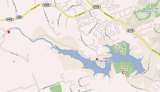
Our plan was to copy the route I have used for training hikes for Philmont and the Guadalupe Mountains. We start at Russell Park (A), hike west on the north side of the lake for ~6 miles, camp at Tejas Camp (B) on the far west side of the lake where the North San Gabriel dumps into the lake, then wake up the next morning and hike ~11 miles east on the south side of the lake until we hit Cedar Breaks Park (C). It ends up being less than 24 hours long and it is about the only way I know of to cover miles like that within 30 minutes of where I live.
Things went as planned except on Friday night a serious thunderstorm rolled in. I was dry and enjoyed the show but I know Drew and Kerry both got a little cold and wet during the night. It didn't end up having a big impact on our trip though so that is good. All in all, I had a great time with very good company.
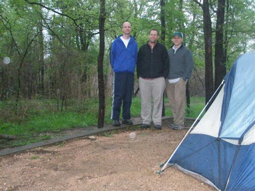
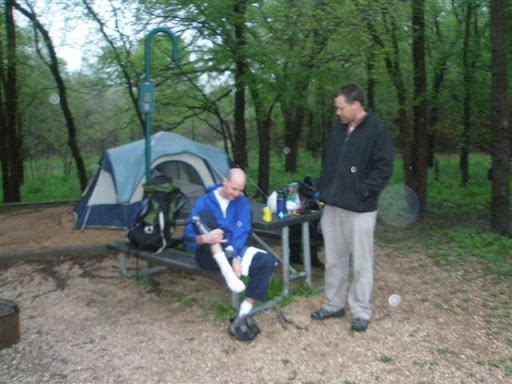
During a break along the way, I stopped to chat with another party. One guy mentioned that the Austin Bike and Trail Club had completed the full loop around Georgetown Lake, making the trail a full 26 mile loop. Of course, now I want to plan a trip to complete the loop. I will be back again in a few weeks with Patrick and Michel, a couple of guys I am hiking the Grand Canyon with. Maybe I will try for it then!
A.T. 2008 - Danby, VT to Grafton Notch, ME
Now that I know I will be heading back to the trail for ~3 weeks this summer, I have had my nose buried in maps and guidebooks every chance I have had.
I am going to pick up where I left off in Danby, VT and hike through to Grafton Notch, ME (~250 miles) or Gorham, NH (~220 miles) depending on how things go. Here is a summary of the plan. The dates may change slightly but this is what I am currently thinking.
All in all, I think I am being pretty conservative with the mileage. There is really only one or two days where I think I might be pushing myself a little too hard. Plus, I will be hiking in the White Mountains above the tree line for a good portion of the time so I want to play it safe. I would rather have the option to hike into Maine or come home a few days early instead of having to push myself to meet an overly aggressive itinerary.
I am really excited for the first week of the hike because most of it includes trails I hiked on while we live in Rutland (White Rocks, Deer's Leap, Spring Lake, etc.....). It will be fun bringing back some of those memories.
Also, if you are interested, here are links to my primary reference materials....
- Appalachian Trail Thru-Hiker's Companion (2007)
- Appalachian Trail Guide to NH-VT (1oth Edition)
I am going to pick up where I left off in Danby, VT and hike through to Grafton Notch, ME (~250 miles) or Gorham, NH (~220 miles) depending on how things go. Here is a summary of the plan. The dates may change slightly but this is what I am currently thinking.
| Day | Shelter/Lodging and Notes | Miles | Day of the Week | Date |
| 0 | Fly to Boston (arrive 9:50 pm on American Airlines) | -- | Tue | July 22nd |
| 1 | Fly to Rutland (arrive 11:10 am on Cape Air). Cab or Friend to Trailhead. Minerva Shelter. | 11.7 | Wed | 23rd |
| 2 | Pico Peak Shelter (apparently Cooper Shelter isn't in good shape.... Thanks Connie!) | 16.8 | Thu | 24th |
| 3 | Stony Brook Shelter (hit Deer's Leap along the way) | 14.0 | Fri | 25th |
| 4 | Thistle Hill Shelter (longest day of the trip.... maybe too long?) | 21.1 | Sat | 26th |
| 5 | Velvet Rocks or hotel in Hanover, NH (resupply and do some laundry) | 14.1 | Sun | 27th |
| 6 | Moose Mtn. Shelter | 11.3 | Mon | 28th |
| 7 | Firewarden's Cabin (on top of Smarts Mtn.) | 12.6 | Tue | 29th |
| 8 | Ore Hill Shelter | 12.6 | Wed | 30th |
| 9 | Jeffers Brook Shelter | 8.5 | Thu | 31st |
| 10 | Eliza Brook Shelter | 15.9 | Fri | 1st |
| 11 | Liberty Spring Tentsite (resupply in N. Woodstock before hiking last couple of miles to campsite) | 11.4 | Sat | 2nd |
| 12 | Galehead Hut (call ahead to make reservation at hut during busy weekend) | 10.4 | Sun | 3rd |
| 13 | Crawford Notch (hostel or hotel) | 14.7 | Mon | 4th |
| 14 | Lake of the Clouds Hut (just down the hill from Mt. Washington. call ahead to make reservation) | 11.2 | Tue | 5th |
| 15 | Pinkham Notch Camp (call ahead to make reservation) | 14.8 | Wed | 6th |
| 16 | Imp Campsite (last night on the trail) | 13.1 | Thu | 7th |
| 17 | Trident Col Shelter (resupply in Gorham, NH) | 13.9 | Fri | 8th |
| 18 | Carlo Col Shelter (right on the NH-ME state line) | 11.1 | Sat | 9th |
| 19 | Speck Pond Campsite | 9.5 | Sun | 10th |
| 20 | Grafton Notch. Shuttle to Pinkham Notch. | 4.6 | Mon | 11th |
| 21 | Concord Coach Lines Shuttle to Boston | -- | Tue | 12th |
| 22 | Fly home (depart 7:30 am on American Airlines) | -- | Wed | 13th |
I am really excited for the first week of the hike because most of it includes trails I hiked on while we live in Rutland (White Rocks, Deer's Leap, Spring Lake, etc.....). It will be fun bringing back some of those memories.
Also, if you are interested, here are links to my primary reference materials....
- Appalachian Trail Thru-Hiker's Companion (2007)
- Appalachian Trail Guide to NH-VT (1oth Edition)
Saturday, March 15, 2008
Mt. Datun
It looks like I will make it back onto the trail in July! I had wanted to pick up where I left off in Vermont but I may end up in Georgia since my sister's family is in Atlanta.
In the mean time, I have decided to post some of my "training hikes" for the AT.
I was traveling in China and Taiwan for the last couple of weeks and one day while visiting with my brother's (Kyle) family in Taipei, I decided to go on an adventure! From my brother's apartment in Zhu Wei you can see a good sized mountain that looks a few kilometers away. I decided to go for it and for the first big hill I was accompanied by Jenny and Abby (sister-in-law and niece). I left them at about 10:00am with a water bottle, a camera, a faint recollection of where they lived and with a strong desire to get to the top of the mountain. What I didn't bring was a map, any food, or my brain apparently!
The hike was actually fairly well marked and started as more of a rural walking path, well marked by the city. I ended up cresting a few summits and realizing the path I was on wasn't leading to my original goal but could now I could see a more attractive goal. I decided to go for it! The well marked trail turned into more of a series of paved marked walking paths broken by narrow winding roads. Luckily the trails had plenty of people on them so I would usually just follow someone else. In the mean time, I climbed what must have been thousands of steps, asked for help at least a few times and passed all kinds of small rural farms, memorials built to ancestors, and views of the smog enveloped city increasingly far away.
After a couple of hours, I arrived at a true trailhead in an off-the-beaten path entrance to a National Park. Now we were getting somewhere.... I saw a map and although I couldn't pick up on all the Chinese there was enough English, meter markers, and maps for me to identify my goal and feel confident that I could make it. I was about 4 km from my goal and it looked like around 2000ft of elevation gain. I still had a good hike ahead of me.
I eventually made my goal at around 1:00pm but was out of water, tired and without food. Time to go home!
As I was about to head down the hill, a nice older couple who had shadowed me on the final ascent asked if I was going back down. After replying that I was, they asked if I had eaten. Nope. I graciously accepted some food (I really have no idea how to describe what it was) and when they learned I didn't have water they gave me a green tomato as well. I was very grateful for their charity (and a little remorseful for my stupidity) and started heading home.
I knew I could retrace my steps and get home but also knew that going the exact way I came required a 1000ft up and down in about a 1.5km space. I wasn't in a condition to attack that so I decide to triangulate a little. I knew there was a junction of two separate trails that I had been on and that it was likely to bypass the mountain. I went for it. The only problem was that as I was walking, very, very thick clouds rolled in and I was not able to find what I was looking for.
Instead I opted to follow the crowds. A bunch of people were heading down through the clouds on a path I was unfamiliar with. I quickly realized this was a good thing and I needed to get out of the mountains and get home. Kyle and Jenny were expecting me around 3:00 and it was clear I was going to miss that mark.
My decision paid off and I ended up a visitor's center on the park's main road. I was able to take care of the most critical thing....hydrating.
Now that I was out of risk of physical harm. How the heck was I supposed to get home? While hiking around I had pondered this point and was able to recall the town they were in (Zhu Wei) and the street where one of their friends lived (Min Zhu Lu) and I knew how to get to their place from there. I was confident that if I could get to a metro stop, I would make it home or at least within a few hundred yards of home. From there, an internet cafe would probably be my last best way of calling for help (of course, I didn't have their phone number with me!)
Luckily, things worked out exactly as planned. I relied heavily on locals who looked like they might know English. 2 busses, 8 metro stops, and 2.5 hours later, I arrived back at the apartment (to at least a little bit of relief from the family!)
OK.... so by now you are thinking, "Craig is an idiot." I would have to agree but said another way, I learned a few things.....
- Plan ahead and don't take off without the plan. I already knew this, of course, but it just goes to show you that you can still make the wrong choices.
- Map, water and food. Dugh!
- I never panicked. I did something right?! Seriously though, it was good for me to observe myself handling the situation well. This was a good thing for my confidence as I follow my desires to head into increasingly challenging adventures.
When it was all said and done, I had climbed from sea level to over 3000ft, probably covered somewhere in the neighborhood of 10km, and had summited nearly the highest peak in that National Park. Not too shabby. I'm just glad the adventure ended the way it did!
I should mention that Anne wasn't impressed! She let me know how silly that was and pointed out that this video could have been what they showed on 60 minutes when they did a special on the American hiker that got lost in Taiwan.
Saturday, September 29, 2007
Tracking Progress
While on the trail, I decided I needed to create a visual way of tracking progress towards my goal. So.... I bought a map of the AT and had it mounted on foam board. Here is my first section marked on the map.


Wednesday, August 15, 2007
Danby, VT
Another night with just me in the shelter. I must have gone to bed too early because I woke up near midnight and couldn't fall asleep. I was up for 3 hours (or so) tossing and turning but eventually I fell back asleep. As usual, I was back up and running by 6:30am. 6:30-10:00am are definitely my best hiking hours. I love to get up and going. I feel strong, I move quickly, and I seem to feel the rhythm of the earth. The already calm woods seem even more serene and I feel like the only person in them. All of this does come with one big caveat though....... spider webs! When you are the first person on the trail you have the joy of clearing all the last nights cobwebs primarily using your face.... I hate that!
 Anyway, I was out of the woods by 10:30am and after a few phone calls I finally got Pop. He was 45min away so I began the 3 mile walk to Danby but after about half of it was able to hitch a ride (a first for me). While waiting for Pop I got a drink and a couple pieces of pizza!! (nice breakfast)
It is weird to be out of the woods and I miss it already. Next year I will come back and finish the last 77 miles of VT. For now, it is time for Gill's, a shower, some laundry, and then maybe a movie.
Bye, AT. I will be back next year!
 Anyway, I was out of the woods by 10:30am and after a few phone calls I finally got Pop. He was 45min away so I began the 3 mile walk to Danby but after about half of it was able to hitch a ride (a first for me). While waiting for Pop I got a drink and a couple pieces of pizza!! (nice breakfast)
It is weird to be out of the woods and I miss it already. Next year I will come back and finish the last 77 miles of VT. For now, it is time for Gill's, a shower, some laundry, and then maybe a movie.
Bye, AT. I will be back next year!
Tuesday, August 14, 2007
Peru Peak Shelter
William Douglas Shelter turned out to be a nice spot. The shelter was made with logs and not all the joints were filled so it had an ole' timey feeling. Then I read the register and the entry before mine was from the previous day. It was the only one that day and it was a shelter inspector.... Needless to say, nobody else showed up and I fell asleep as the coals of the fire were still glowing. I must have slept well too because I woke up a little later than usual. I had packed the night before though so within 15 min, I had hit the trail... probably before 7:00am still but I can't be sure.
The morning's hike was pretty uneventful but I found myself thinking of Anne and the boys. It will be good to see them in a couple of days. Bromley was pretty cool. The clearing for skiers at the top along with the observation deck made for some nice views. I pressed on and stopped to have my lunch at the base of Styles Peak on Mad Tom Notch Road. That ended up being a good thing for two reasons. I had just run out of water (bad planning).....
 ...... and the hike up Styles Peak was a kick in the nuts. It reminded me of the hike up Maple Hill coming out of VT-9. I was dying by the time I got to the top. I also noticed that my feet started hurting a lot sooner today. I should see a foot specialist before coming out on to the AT again. The pain is enough to really slow me down sometimes. In the end I still averaged around 2 miles/hour and arrived at Peru Peak Shelter around 3:00pm. First things first, I dropped everything and headed over to Griffith Lake for a dip..... tired feet or not, I was walking the 1/2 mile for a swim!
 When I got there there was a couple. The guy was in the nude (getting dressed after a dip) and apparently I had just missed the wife doing the same. They were a very nice couple from New Hampshire up here for the weekend. Turns out he is quite the mountaineer and had lead groups up Mt. Rainer. We had a good conversation and they seemed to know something about feet and suggested I needed support for my "transverse" arch. Sounds good to me!
This shelter is a good one for my last night. There is a stream running about 20ft from the shelter and the sound is completely calming and hypnotic. It will be fun to fall asleep to that tonight.

I will be hiking out tomorrow (7.5 miles to the trailhead, and another 3.2 to Danby) and based on my pace, I will be there before lunch. I don't think Pop was expecting such an early arrival. Hopefully I will be able to get a cell call to him to minimize the waiting around. First thing I am going to do is shower (at the VAC?) then go over to Gill's for a veggie with bacon. I can hardly wait!
I still have a few hours before I am going to go to sleep but so far the day has been great.
Lost items:
- Headlamp (crap!)
The morning's hike was pretty uneventful but I found myself thinking of Anne and the boys. It will be good to see them in a couple of days. Bromley was pretty cool. The clearing for skiers at the top along with the observation deck made for some nice views. I pressed on and stopped to have my lunch at the base of Styles Peak on Mad Tom Notch Road. That ended up being a good thing for two reasons. I had just run out of water (bad planning).....
 ...... and the hike up Styles Peak was a kick in the nuts. It reminded me of the hike up Maple Hill coming out of VT-9. I was dying by the time I got to the top. I also noticed that my feet started hurting a lot sooner today. I should see a foot specialist before coming out on to the AT again. The pain is enough to really slow me down sometimes. In the end I still averaged around 2 miles/hour and arrived at Peru Peak Shelter around 3:00pm. First things first, I dropped everything and headed over to Griffith Lake for a dip..... tired feet or not, I was walking the 1/2 mile for a swim!
  When I got there there was a couple. The guy was in the nude (getting dressed after a dip) and apparently I had just missed the wife doing the same. They were a very nice couple from New Hampshire up here for the weekend. Turns out he is quite the mountaineer and had lead groups up Mt. Rainer. We had a good conversation and they seemed to know something about feet and suggested I needed support for my "transverse" arch. Sounds good to me!
This shelter is a good one for my last night. There is a stream running about 20ft from the shelter and the sound is completely calming and hypnotic. It will be fun to fall asleep to that tonight.

I will be hiking out tomorrow (7.5 miles to the trailhead, and another 3.2 to Danby) and based on my pace, I will be there before lunch. I don't think Pop was expecting such an early arrival. Hopefully I will be able to get a cell call to him to minimize the waiting around. First thing I am going to do is shower (at the VAC?) then go over to Gill's for a veggie with bacon. I can hardly wait!
I still have a few hours before I am going to go to sleep but so far the day has been great.
Lost items:
- Headlamp (crap!)
Subscribe to:
Posts (Atom)
.JPG)